MIAMI — Powerful Irma hit maximum Category 5 status early Tuesday Sept. 5, with a hurricane hunter plane measuring winds topping 175 mph, National Hurricane Center forecasters said.
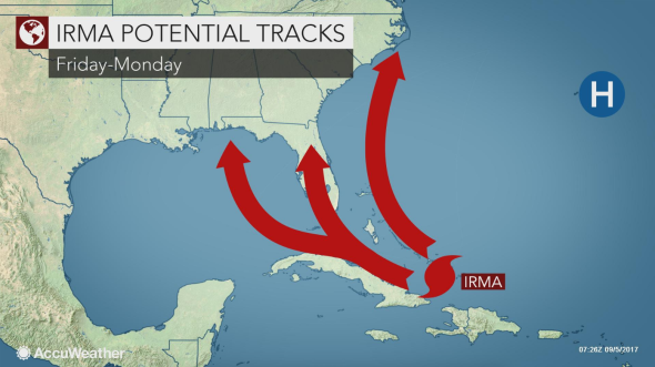
The Miami Herald reported that as the hurricane churns closer to the U.S. coast, its path becomes more certain, with South Florida increasingly likely to take a hit. Tropical storm force winds could arrive as early as Friday. Gov. Rick Scott has declared a state of emergency for all 67 Florida counties and was set to spend much of Tuesday morning in hurricane briefings.
Irma is expected to begin battering the northern Leeward Islands later today, with a storm surge reaching between six and nine feet and pounding waves. Fierce hurricane winds extend 45 miles from its center.
The Virgin Islands and Puerto Rico are expected to get hit later in the week.
Tropical storm force winds are likely to begin hitting South Florida by Friday. National Hurricane Center
At 8 a.m. Tuesday Sept. 5, Irma was located 270 miles east of Antigua, heading west at 14 mph. While wind speeds could fluctuate over the next day or two, forecasters say it will likely remain a very dangerous Cat 4 or 5 storm as it heads westward.
Hurricane warnings and watches extended across the Caribbean, with vulnerable islands prone to dangerous mudslides paying careful attention. Last year, Hurricane Matthew struck Haiti last year as Cat 4 storm, leaving thousands homeless. On Tuesday morning, hurricane warnings covered much of the north end of the Leeward Islands, including Antigua, Barbuda, Anguilla, Montserrat, St. Kitts, and Nevis as well as the U.S. and British Virgin Islands and Puerto Rico. Hurricane watches were in in effect for Guadeloupe and parts of the Dominican Republic.
Monroe County (the Florida Keys) plans to activate its emergency operations center at noon today to begin announcing evacuation plans. Evacuations are generally ordered for any storm at Cat 1 strength or higher.
While models have shifted Irma’s path up and down over the weekend, Tuesday morning’s runs largely agree on the storm’s path over the next three days, with less certainty after that. A powerful high pressure ridge that has been steering Irma remains strong, forecasters said, keeping it on a westward path.
After 24 hours, Irma is expected to turn slightly to the west, northwest, forecasters said. After four and five days, the storm’s track is less certain, with a margin of error of between 175 and 225 miles.
Over the last week, Irma has undergone repeated eyewall replacements, a common structural change for such massive storms. While the replacement may initially weaken the storm, it allows it to spread and grow in size. With each replacement, Irma has also been able to regain steam.
Source: miamiherald.com


