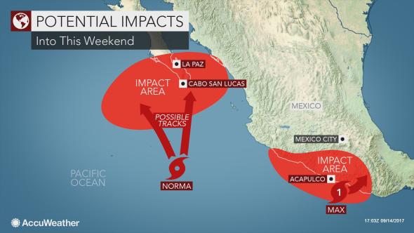
Into the weekend Sept. 16-17, several tropical systems could make an impact on Mexico entering from the Pacific Ocean, while far out in the southeastern Atlantic two storms hold the possibility of reaching Mexico’s Caribbean coast….
On Thursday Sept. 14 in the morning, local time, Max became a hurricane on the southern side of Mexico. This system was continuing to track slowly northeastward towards the coast on Thursday, making landfall sometime in the early afternoon.

Once moving inland, Max will weaken very quickly, due to the mountainous terrain. Despite weakening, the tropical moisture will still follow the system, moving into areas from coastal Michoacan to southern Oaxaca.
“Max will bring the biggest threat for flooding across the state of Guerrero, including Acapulco, into Friday morning,” said AccuWeather Meteorologist Steve D. Travis.
With days of accumulating rainfall, a total of 25 to 75 mm (1 to 3 inches) is possible in the area. There could be locally higher amounts well over 150 mm (6 inches), especially in the higher terrain farther inland. Rainfall of this magnitude could bring mudslides, warned Travis.
Although less intense rain is expected in these for southern Oaxaca, any longer stretches of rain could hinder any cleanup efforts going on in the region following the 8.1 magnitude earthquake that happened just off shore last week.
Coastal areas, especially east of the center of the storm, will get the strongest wind gusts, as well as the biggest storm surge.
Max is not the only tropical system that could make landfall in Mexico in the near future.
Just to the northwest of Max is Norma, which became a tropical storm Thursday morning. Norma, could again put Mexico on alert for tropical moisture for the weekend.

“Norma is likely to become a hurricane as it churns in the warm waters of the East Pacific” said Travis.
“While the track is not set in stone, it could move northward toward the Baja Peninsula or western Mexico late in the weekend,” Travis added.
Should Norma track closer to land, flooding rainfall and gusty winds would also impact the area, in addition to the potential for storm surge.
But this track is just one possibility. The storm could also curve northwestward in the next few days, missing the Baja Peninsula completely.
“The longer Norma takes to strengthen, the better chance that the tropical low misses the Baja Peninsula,” said AccuWeather Hurricane Expert Dan Kottlowski.
Even without a landfall, the southern and western coasts of the Baja could experience rough surf and rip currents into next week.
While the Pacific weather systems were the focus of most attention in Mexico Friday, the National Hurricane Center in Miami was also watching two storms in the far southeast Atlantic that posed the threat of reaching hurricane strength in about five days. Either or both of these systems could become hurricanes that could eventually threaten Mexico’s Caribbean or Gulf coasts.
Source: accuweather.com


