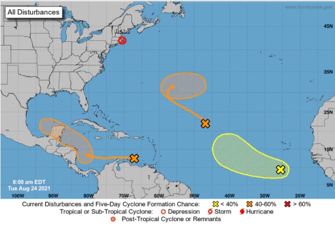
The National Hurricane Center is watching three areas of interest Tuesday morning, all with medium-to-high odds of becoming the next tropical depression or storm.
First, meteorologists are looking at a broad trough of low pressure, which is producing disorganized showers and thunderstorms about 900 miles west-northwest of the Cabo Verde Islands, according to the NHC’s 8 a.m. update.
Not much development is in store for the short-term forecast. Still, Atlantic conditions increase favorably later this week, giving this disturbance a 20% chance of forming into a tropical depression in the next two days and a 60% chance of doing so in the next five.
Next, the NHC has its eyes on a tropical wave with a 60% chance of becoming a depression in the next five days. The wave is expected to form a broad area of low pressure over the southwestern Caribbean Sea later this week. Slow development is forecast as it moves west-northwestward over the northwestern Caribbean Sea.
Finally, meteorologists are also keeping watch over a tropical wave about 400 miles south-southwest of the Cabo Verde Islands. The wave has become better organized, according to the NHC, and has a 20% chance of developing in the next two days and a 30% chance of doing so in the next five.
Presently, the wave is forecast to move westward at 10 to 15 mph over the eastern tropical Atlantic.
To become tropical storms and receive names, the system would next organize a circular flow of air and require maximum sustained winds of 39 mph or more.
The following three tropical storm names are Ida, Julian, and Kate.
For now, none of the disturbances have a projected path toward Florida.
Further north, Henri became a post-tropical cyclone and is 50 miles east of Providence, Rhode Island. The storm has maximum sustained winds of 25 mph and is moving east at 14 mph. Henri is expected to dissipate by Wednesday morning.
Source: The National Hurricane Center
TYT Newsroom


