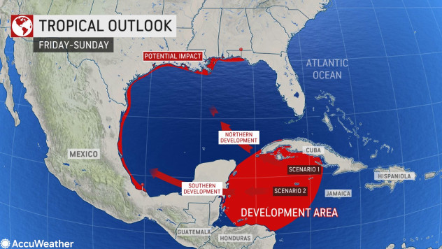
AccuWeather meteorologists project that a tropical wave sweeping through the Caribbean Sea will have a high likelihood of becoming a named system as it nears Central and North America later this week and into early next week. Areas of Mexico that were ravaged by Hurricane Grace may again be in the path of this new tropical threat, and forecasters cannot rule out the potential for a future direct impact in the United States.
The feature under scrutiny, designated as Invest 99L by the National Hurricane Center, remained largely disorganized during the early part of this week as it produced showers and breezy conditions across parts of the Caribbean and northern portions of South America.
Tropical development is not expected to occur through at least Thursday due to increasing wind shear in the path of the disturbance.
“Even if it does not strengthen in the short-term, the tropical wave can enhance showers and thunderstorms through Thursday across Jamaica and the Cayman Islands, two areas that were also pummeled by Grace’s heavy rain last week,” AccuWeather Senior Meteorologist Adam Douty said.
 |
| This satellite image captured early Wednesday morning, Aug. 25, 2021, shows an area of disturbed weather in the Caribbean Sea that forecasters are monitoring for tropical development in the coming days. (AccuWeather Enhanced RealVue™ Satellite) |
Wind shear is expected to lessen in the northwestern Caribbean later this week, and if the tropical wave does not organize prior to that point, forecasters expect it to have a greater chance for development once it enters this zone.
“The overall environment appears to be quite favorable for development perhaps as early as Friday, but more likely Saturday,” AccuWeather Hurricane Expert Dan Kottlowski said.
It is during these days that the brewing tropical threat can deliver another round of heavy rainfall and gusty winds to the Yucatán Peninsula, where Grace made landfall as a Category 1 hurricane last week. Ongoing clean-up operations may be hindered, and new or worsening flooding problems could result.
Should this system become a tropical storm (maximum sustained winds of 39-73 mph, or 62-117 km/h) or stronger prior to its closest pass near or over the Yucatán Peninsula, the risk for damaging winds would be higher.
This tropical wave will be competing with two other areas of disturbed weather in the Atlantic basin to become the next named storm of the season. The next names on the list are Ida and Julian.
Forecasters say that the longer-range path of this potential tropical threat still has plenty of moving parts that need to be ironed out in the days to come.
There are a wide range of possible ideas on movement and intensity of this system due to the fact that a center at the lowest levels of the atmosphere has not formed yet, according to Kottlowski.
 |
A system that remains on the weaker side will tend to take more of a westerly path, perhaps emerging from the Yucatán Peninsula and into the Bay of Campeche in the southwestern Gulf of Mexico later this weekend into early next week. Weaker systems tend to be guided along by the wind in the lowest part of the atmosphere.
In this scenario, some of the same areas of eastern Mexico that bore the brunt of Grace’s peak intensity as a Category 3 hurricane could again be struck by heavy rainfall and gusty winds.
On the other hand, a stronger, more organized system would tend to take a more northerly track into the heart of the Gulf of Mexico. Stronger systems are steered more by the larger-scale weather pattern, which in this case would be the clockwise flow around the Bermuda High.
 |
“Earlier this week, it appeared that this high pressure area would remain strong and extend westward all the way to the southern Plains,” AccuWeather Senior Meteorologist Alex Sosnowski said.
This setup would tend to block any northward path.
“However, it now appears that this high may weaken just enough over the lower Mississippi Valley to create an avenue for any well-developed storm in the Gulf of Mexico to possibly move northward,” Sosnowski explained.
This latter scenario could result in a rapidly strengthening tropical system in the Gulf of Mexico and a potential hurricane taking aim at the Gulf Coast. AccuWeather forecasters say the potential for a landfalling tropical system cannot be ruled out at this time.
“All residents and concerns in the Yucatan Peninsula and across northeast Mexico and southern and even East Texas should closely monitor this system,” Kottlowski said.
Given the range in possibilities, AccuWeather meteorologists say it’s important to check back for the latest updates as more details emerge and the forecast becomes further refined.
Source: AccuWeather.com
TYT Newsroom


