
Forecasters are watching a disturbance in the Gulf of Mexico and two systems in the central and eastern Atlantic, one of which is forecast to turn into a tropical depression soon.
The system with a 70% chance of formation in the next 48 hours and a 90% chance of formation through the next five days was about 900 miles east-southeast of the southern Windward Islands, according to a National Hurricane Center advisory at 8 a.m. Monday.
Forecasters say it could be a tropical depression by the time it reaches the Windward Islands Tuesday night or while moving west across the southern Caribbean Sea Wednesday through Friday. If it does strengthen further into a tropical storm, it would be named Bonnie.
“Interests in the Windward Islands and along the northeastern coast of Venezuela should monitor the progress of this system, and tropical storm watches or warnings could be required for portions of these areas later today,” the hurricane center’s advisory reads. “Regardless of development, locally heavy rainfall is possible over the Windward Islands and the northeastern coast of Venezuela Tuesday night and Wednesday.”
Storm models show this system staying south, even if it does form into a depression or tropical storm. Forecasters predict that a strong ridge of high pressure over Florida is likely to ward the system off.
A hurricane hunter aircraft will investigate the system Monday afternoon.
The other two systems forecasters are watching, one in the northern Gulf of Mexico and another in the eastern Atlantic, have a low 20% chance of formation through the next five days.
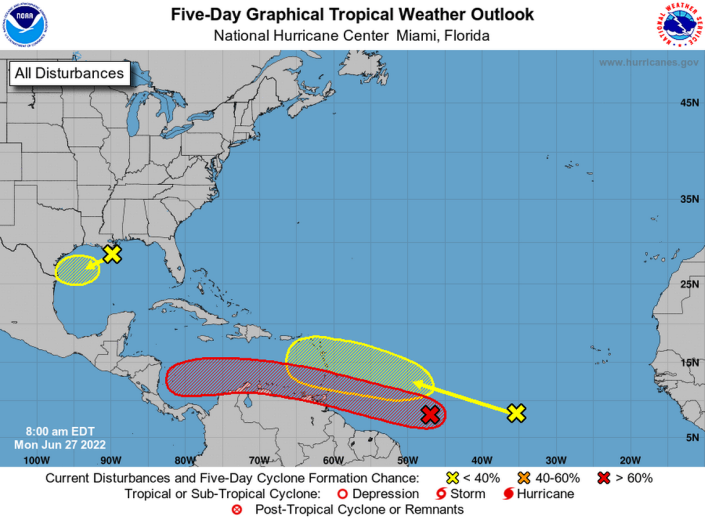
The system in the northern Gulf of Mexico near Louisiana is forecast to move west-southwest and approach the coasts of southern Texas and northeastern Mexico during the next few days.
As for the tropical wave in the eastern Atlantic that is several hundred miles southwest of the Cabo Verde Islands, forecasters say it could see some gradual development later this week as it quickly moves west-northwest over the Atlantic.
TYT Newsroom
