The Atlantic hurricane season’s second named storm formed in an unusual spot—and it’s set to take an even more unusual track.
(TWN).- Tropical Storm Bonnie formed in the southern Caribbean Sea on Friday with maximum sustained winds of 75 km/h. The system will make landfall on the east coast of Nicaragua on Saturday morning, more or less maintaining its current strength as it pushes inland.

Forecasters with the U.S. National Hurricane Center (NHC) expect the storm to produce heavy rainfall along its path. Heavy tropical rains in Central America are exacerbated by the region’s mountainous terrain, which makes flash flooding and mudslides a significant threat in any landfalling system.
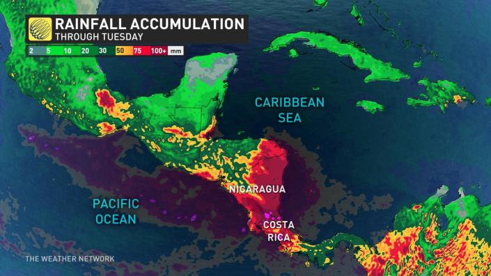
More than 100 mm of rain could fall across portions of Nicaragua and Costa Rica through the weekend, which could lead to life-threatening flash flooding for communities in the affected areas.
It’s unusual for a tropical storm to form this far south in the Caribbean Sea. Most storms track farther north, closer to the Antilles. This storm, and the disturbance from which it formed, hugged South America as it traversed the Caribbean this week.

—
But what’s even more unusual is that the NHC expects Tropical Storm Bonnie to survive its encounter with Nicaragua and emerge over the eastern Pacific Ocean. The mountains of Central America typically tear a storm apart, but Bonnie is moving fast enough that its center of circulation should survive the short trip over land.
If the tropical storm completes its oceanic exchange and survives into the eastern Pacific later this weekend, the storm will keep the name Bonnie as forecasters track it up the western coast of Mexico.
Conditions here are favorable for Bonnie to gradually strengthen into a hurricane through early next week. Residents and visitors to coastal towns on Mexico’s west coast will have to closely monitor the track of the storm in the coming days.


