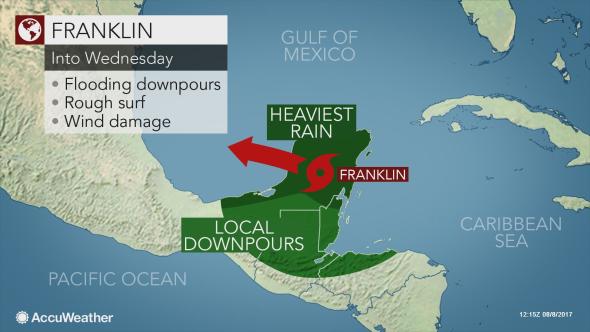
Franklin formed over the western Caribbean Sea on Sunday and made its first landfall near Pulticub, Quintana Roo, at approximately 11:45 p.m. EDT on Monday.
Franklin had maximum-sustained winds of 60 mph as it slammed onshore along the east coast of Mexico’s Yucatan Peninsula Monday night.

Wind gusts capable of causing damage and power outages, as well as dangerous flash flooding, will continue to threaten lives and property across the Yucatan Peninsula into Tuesday afternoon.
“The greatest impacts will be near coastal areas of the peninsula through Tuesday morning,” according to AccuWeather Meteorologist Kyle Brown.
Mexican authorities made preparations for the storm on Monday and set up shelters, cleared storm drains, closed airports and evacuated low-lying areas on the Caribbean coast, according to ABC News.
Franklin will also impact Honduras and Nicaragua, Belize, southeastern Mexico and northern Guatemala with localized flooding downpours and the risk of mudslides through Tuesday.
“The heaviest rainfall is expected across the eastern Yucatan, north of Belize, where rainfall amounts of 4-8 inches, with localized amounts up to 10 inches, are expected,” Brown added.

Seas and surf will remain rough in the region, posing a risk to bathers and boaters.
Life-threatening flooding, damaging winds and rough seas will continue to batter the Yucatan Peninsula through at least Tuesday afternoon before Franklin emerges into the Bay of Campeche.
Franklin will lose some of its intensity as it crosses the Yucatan Peninsula and is temporarily cut off from the anomalously warm waters of the western Caribbean.
“After some weakening occurs into Tuesday, Franklin is likely to restrengthen over the southwestern Gulf of Mexico Tuesday night and Wednesday,” AccuWeather Hurricane Expert Dan Kottlowski said.
AccuWeather meteorologists are projecting Franklin to be close to hurricane strength prior to a second landfall in Mexico.
“Franklin will make landfall south of Tampico and north of Veracruz, Mexico, on Thursday morning.”

Residents and visitors from Veracruz to Tampico, Mexico, should make the necessary preparations for Franklin’s landfall with flooding rain, damaging winds, an inundating storm surge and mudslides.
“Rainfall amounts of 8-16 inches are likely over northern Veracruz, southern Tamaulipas, San Luis Potosi and northern Hidalgo later this week,” Brown added.
In addition to flooding and mudslides, eastern Mexico may also face widespread tree damage and lengthy power outages. The intensity of the storm as it makes its second landfall will determine the extent of structural damage and coastal inundation.
In the case that Franklin strengthens into a hurricane, wind gusts of at least 80 mph are possible near coastal regions of northern Veracruz.
As the storm drifts inland and weakens, its leftover moisture will be squeezed out of the atmosphere like a sponge along the steep eastern slopes of the Sierra Madre Oriental. The risk of life-threatening flooding and mudslides will continue into the end of the week as a result.
There is the potential for locally heavy rain and isolated flooding as far west as Mexico City.
High pressure nosing over the northern Gulf of Mexico is expected to prevent Franklin from turning northward to Texas. However, rain may still graze South Texas, and rough seas may endanger swimmers all along the state’s coastline as Franklin moves into Mexico.
Meanwhile, downpours not associated with Franklin will move westward across the northern islands of the Caribbean early this week. Later this week, a tropical system, dubbed 99L, could also have some impact on the Leeward Islands.
Source: accuweather.com


